Gazette Notification of Permanent Forest Estate in AnapMuput FMU
Anap Protected Forests
| Gazette Date | Gazette No. | Anap Protected Forest | Division | District | Area (Acres) | Officer in Charge |
| 12-08-37 | 1066 | Anap Protected Forest | 4th | Bintulu, Mukah and Tatau | 128,250 | B.J.C Spurway |
| 12-08-41 | 1141 | Pelugau Muput Protected Forest | 3rd & 4th | Mukah & Bintulu | 32,830 | D.B. Stewart |
| 26-02-54 | 1660 | Mersing Protected Forest | 4th | Bintulu | 50,000 | J.H. Ellis |
| 15-12-56 | 1141 | Anap Protected Forest (Extension) | 4th | Bintulu | 152,500 | J.H. Ellis |
| 01-03-58 | 587 | Anap Protected Forest | - | Amalgamation | - | J.C.H. Barcroft |
| 30-07-64 | 1394 | Anap Protected Forest (Excision) | 4th | Bintulu | 3,570 | Bujang Mohammed Nor |
| 01-06-66 | 1040 | Anap Protected Forest (2nd Excision) | 4th | Bintulu | 5,250 | Ignatius Angking |
Mukah Hills Protected Forests
| Gazette Date | Gazette No. | Anap Protected Forest | Division | District | Area (Acres) | Officer in Charge |
| 31-01-36 | 199 | Paku Protected Forest | 3rd | Oya and Dalat | 26,000 | Thomas Corson |
| 11-03-38 | 314 | Selangau Protected Forest | 3rd | Mukah-Balingian | 66,429 | Thomas Corson |
| 12-08-41 | 1141 | Pelugau Muput Protected Forest | 3rd & 4th | Mukah and Bintulu | 12,370 | D.B. Stewart |
| 15-08-54 | 743 | Lombok Protected Forest | 3rd | Mukah | 38,400 | J.H. Ellis |
| 01-09-56 | 1102 | Ulu Mukah Protected Forest | 3rd | Mukah | 100,500 | J.C.H. Barcroft |
| 13-06-58 | 790 | Mukah Hills Protected Forest | - | Amalgamation | - | J.C.H. Barcroft |
| 18-01-85 | 761 | Mukah Hills Protected Forest (1st Extension) | 3rd | Dalat | 25,200 | James Jimbun |
| 04-09-97 | 54 | Mukah Hills Protected Forest (1st Excision) | Sibu | Balingian | 1,816 | Haji Zaidi K. Zainie |
| 20-05-03 | 2254 | Mukah Hills Protected Forest (2nd Excision) | Sibu | Selangau | 2,034 | Datu Haji Hamzah Haji Drahman |
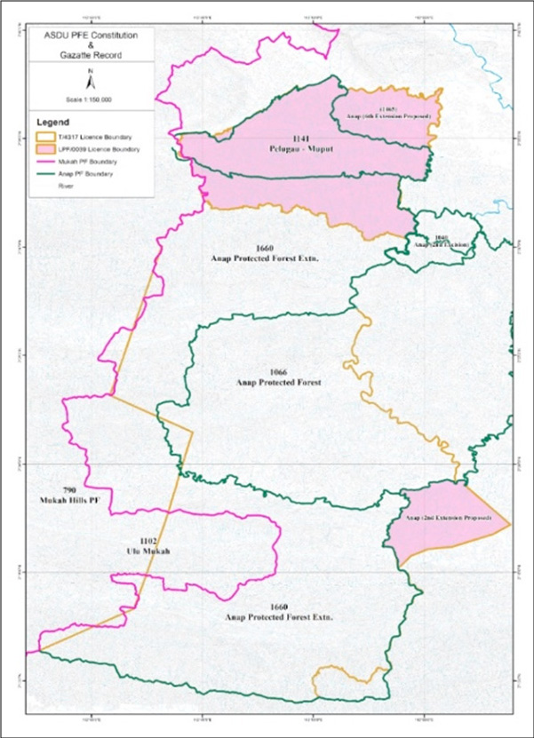
Map showing ASDU PFE Constitution & Gazette Record

Location of Settlements within Anap Mupt FMU
| Settlement | Location | Description |
| Rh. Andrew (Former Mawang ak Matsite) |
2°18.828'N, 112°54.396'E |
Approx. 1km downstream from Ng Belawit, Ulu Anap |
| Rh Philip (Formerly Bilong ak Entalang) |
2°19.294'N, 112°55.984'E |
Ng Rengas, Ulu Anap |
| Rh Gasah ak Subang |
2°19.255'N, 112°55.771'E |
Approx. 2km upstream from Ng Takan, Ulu Anap |
All the settlements located within AMFMU are located on the bank of Batang Anap.
There are 8 settlements within 5 km of the FMU boundaries:
| Settlement | Location | Description |
| Rh Marayang (Formerly Gerina ak Rumau) |
2°31.687'N, 112°54.737'E |
Ng Malat, Batang Anap |
| Rh Entrie ak Anju |
2°19.405'N, 112°56.433'E |
Ng Takan, Batang Anap |
| Rh Sayong ak Murapi |
2°19.166'N, 112°55.843'E |
Anap Belawit Management Area (LPF/0039) |
| Rh Mawang ak Mat |
2°17.961’N, 112°55.240’E |
Anap Belawit Management Area (LPF/0039) |
| Rh Bilong ak Entalang |
2°18.084’N, 112°56.619’E |
Anap Belawit Management Area (LPF/0039) |
| Rh. Johnny ak Mancha (Formerly Rh Mancha) |
2°28.435'N, 112°51.682'E |
Ng Beringit, Batang Anap |
| Rh Anai ak Sain (Formerly of Rh Mancha) |
2°28.435'N, 112°51.682'E |
Ng Beringit, Batang Anap |
| Rh Dumin ak Jimbun |
2⁰34' 12.947"N, 112⁰52' 24.63"E |
Km 58 Tatau Muput road (LPF/0039) Anap PF |